
Oblique 3D capture missions for DJI drones
A nadir grid maps the ground; obliques capture everything standing on it. This mission flies angled perimeter passes over and around your site, photographing façades and elevated features from the directions you choose — the other half of a complete 3D reconstruction.
Angled passes that look outside-in
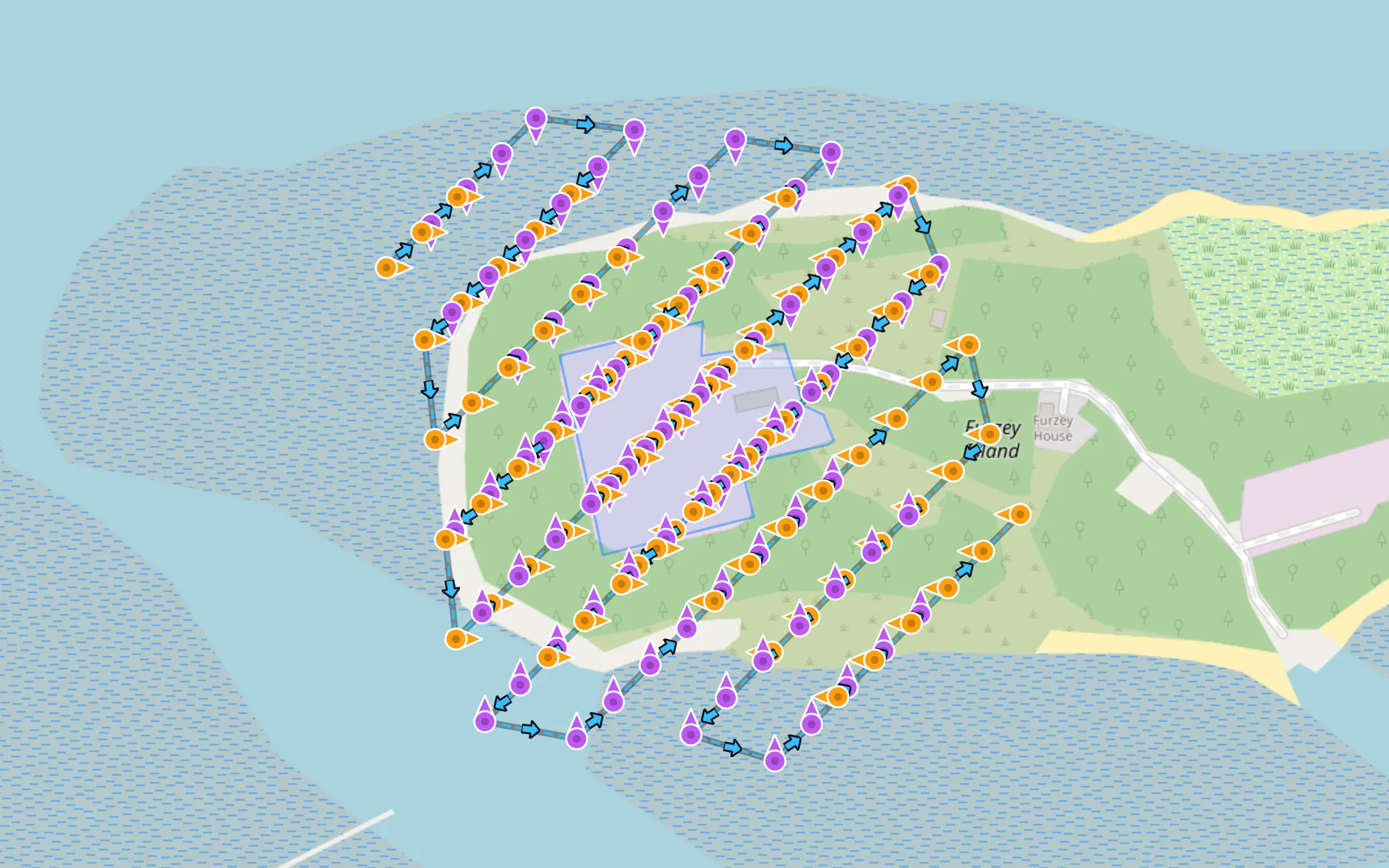
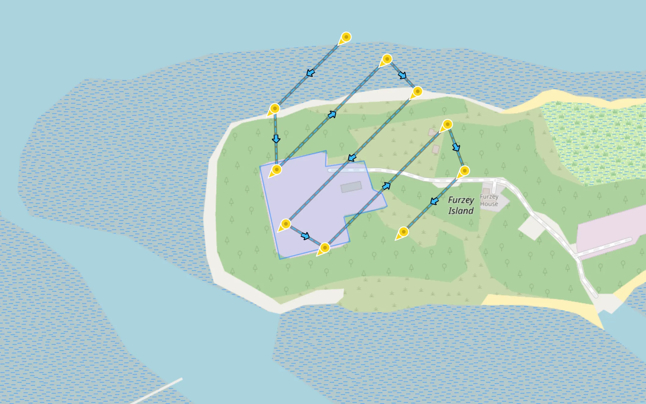
Draw the area and the planner buffers it outward, so the perimeter faces are photographed from outside looking in — not clipped at the boundary. The GSD is slant-aware: computed at the centre of the tilted frame along the actual viewing distance, so your resolution target means what it says. Photo spacing comes from the real oblique footprint geometry, with a keep-test that only shoots frames whose view centre lands in your area.
Eight headings, one mission
In interval capture you pick from eight compass headings — each flown with the aircraft heading locked, shooting on a timer, and Combine Headings merges them into a single mission file with smooth transitions between one heading and the next. In waypoint capture, four direction pairs sweep the site with the gimbal pitch you set, ordered to minimise gimbal rotation between shots.
Built to pair with a mapping grid
Obliques and nadir are complements, not competitors: fly an orthomosaic mapping grid for the ground and this mission for everything vertical, and feed both photo sets into WebODM, Metashape, Pix4D or RealityCapture together. For a single building rather than a whole site, an orbit mission or façade mapping may fit better — façade mapping can now take the roof as well as the walls, at the same close standoff (Advanced).
Preview the passes against the real site
Two overlays make the plan concrete before anything flies. A GeoTIFF orthomosaic from an earlier flight replaces stale satellite tiles with current, high-resolution imagery for drawing your area. And if you already have a mesh of the site — even a rough one from a previous quick pass — load it as a 3D Model Overlay: it appears seated on the terrain in the 3D preview, so you can eyeball the angled passes against the actual structures they're meant to capture. Both are visual references, processed entirely in your browser and never uploaded. More on planning with real-world context →
Terrain, preview, export
Terrain Follow keeps the passes at consistent height over sloped ground — baked into the mission the way consumer DJI drones actually fly (relative to take-off). Check the route in the interactive 3D preview, then export a DJI KMZ (WPML) for the Mini 4/5 Pro, Air 3/3S, Mavic 3 series, Mavic 4 Pro or Lito X1 — plus an experimental Litchi CSV option in waypoint capture. Matrice 300/350 RTK, Mavic 3E/3T/3M and Inspire 3 pilots get the same missions as stop-and-shoot waylines for DJI Pilot 2.
Oblique capture, asked and answered
Why fly obliques at all if I already have a nadir grid?
Straight-down photos barely see walls, so reconstructions of buildings come out melted. Angled passes look at the site from the side, giving the reconstruction software the geometry it needs for façades and elevated features. Best paired with an ortho mission for a complete dataset.
Is the GSD accurate when the camera is tilted?
Yes — the GSD here is slant-aware: it's computed at the centre of the tilted frame along the actual viewing distance, not straight down. Altitude and GSD stay linked through your drone's real camera geometry.
What's special about oblique interval capture?
Each of the eight compass headings is flown with the aircraft heading locked, shooting on a timer — and Combine Headings merges them into a single mission file with smooth transitions between headings.
Other mission types
Plan your first oblique mission
Create a free account, draw an area and see the angled passes before you fly.