
Smart 3D Capture for consumer DJI drones
Mesh-based mission planning used to mean an enterprise rig — a Matrice flying DJI's own Smart 3D Capture from DJI Pilot 2. Here you plan the same kind of surface-guided, obstacle-aware flight on a real 3D model of your site, and fly it on the drone you already own.
Mark what to capture — on the mesh itself
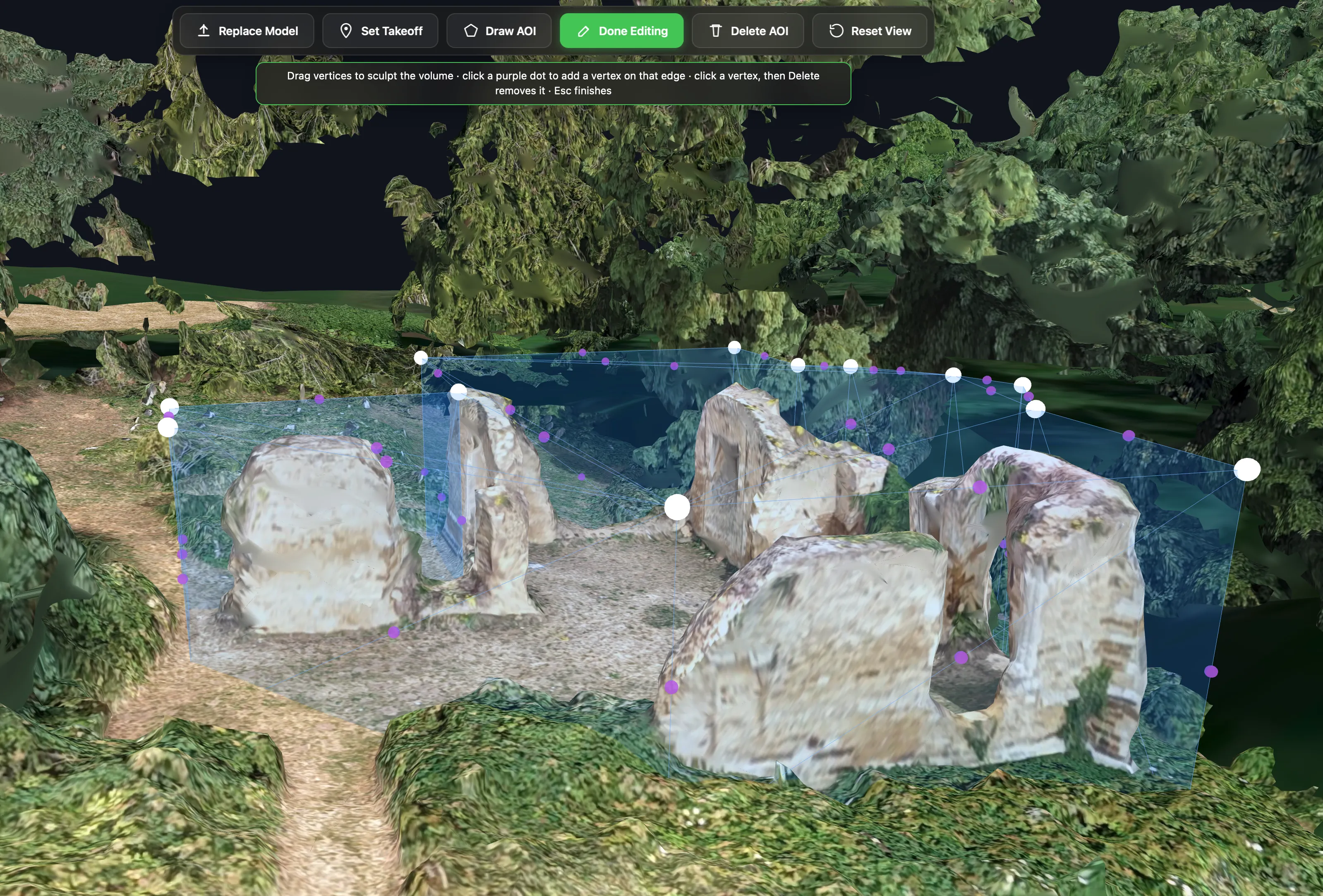
Upload a georeferenced 3D mesh (OBJ / GLB) of the structure and its surrounding terrain — from a quick oblique first pass processed in WebODM, Metashape or Pix4D, or a model you already have. A short wizard georeferences it (EPSG code, or a local frame with an origin), then you draw your area of interest directly on the model in 3D: click the surfaces you care about, pull the volume up to height, done. No guessing from a top-down map.
Smart Loops: coverage that wraps the structure
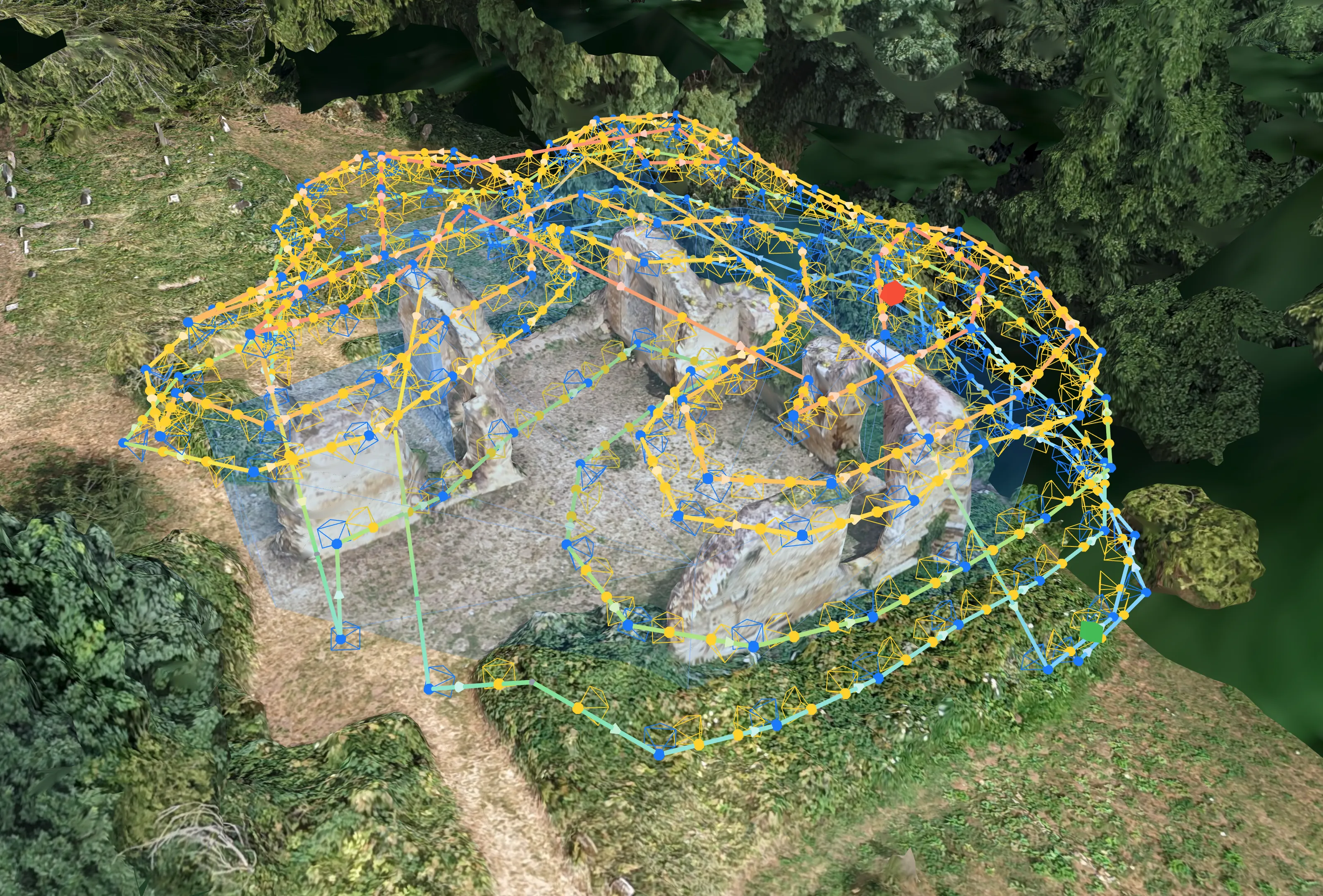
One click generates the route: closed loops that wrap around the structure at your standoff distance, climbing bottom-up and closing over the top. Cameras aim straight-on at walls, nadir at the roof, and sweep smoothly across the shoulder in between — with Intelligent Obliques angling extra shots for a complete reconstruction. It's the pattern a Matrice 4E flies in DJI's own Smart 3D Capture, planned against your own mesh.
Obstacle avoidance that starts at the plan
The whole mesh is treated as an obstacle — including the parts outside your area of interest. Every waypoint and every leg between waypoints is planned to keep your chosen Obstacle Clearance from the model and from steep terrain. Transit legs route over or around the structure (never under it), detours hug the geometry instead of ballooning away from it, and if a region genuinely can't be reached safely the mission is split into separate flights rather than flown through the obstacle. In flight, your drone follows that plan to the accuracy of its GNSS fix — so size your clearance with that margin in mind (the defaults already are), and keep onboard obstacle sensing active: the plan works with it, not instead of it.
A Max Altitude Ceiling (default 120 m above take-off, matching most drone regulations) caps waypoints and detours alike, and a minimum height to ground keeps the route out of the grass. Set your target detail as a GSD or a standoff distance — the two are linked — and front/side overlap control loop spacing and shot spacing on the surface.
What it needs, and what it doesn't do
The mesh must be georeferenced and should include the terrain around the structure; a bare-earth DTM (Digital Terrain Model) from the same photogrammetry job is recommended to refine ground heights. Your original file is parsed entirely in your browser — only a small, decimated planning copy is sent to the server. Three honest limits: Smart Loops is a heightfield pattern, so undersides and overhangs are out of scope (exactly as on the Matrice); mesh missions export as DJI KMZ (WPML) only — no Litchi CSV for this type; and a consumer drone flies the plan to GNSS accuracy — typically ±2–3 m, not to the centimetre like an RTK-equipped Matrice (also supported now: select a Matrice 300/350 and the same mission exports as a stop-and-shoot wayline with relaxed margin warnings). The default standoff and clearance are sized to absorb that error, and the planner warns you when you set them tighter.
Flown by the drone you already own
The result is a standard KMZ (WPML) waypoint mission: load it in DJI Fly and a DJI Mini 4 Pro, Mini 5 Pro, Air 3/3S, Mavic 3, Mavic 4 Pro or Lito X1 flies it natively — or import it in DJI Pilot 2 for a Matrice 300/350 RTK, Mavic 3E/3T/3M or Inspire 3, where every capture becomes a stop-and-shoot waypoint action. Long missions split automatically at your waypoint cap, so complex structures come out as a numbered series of flights.
Smart 3D Capture, asked and answered
Do I need an enterprise drone for mesh-based missions?
No. The mission exports as a standard DJI KMZ (WPML) waypoint file, so a Mini 4 Pro, Air 3S or Mavic flies it natively — the mesh intelligence happens at planning time, in your browser and on our servers, not on the drone.
Where do I get a 3D mesh of my site?
A quick oblique first pass processed in WebODM, Metashape or Pix4D produces a georeferenced OBJ or GLB — or use a model you already have. The mesh should include the terrain around the structure.
Can it capture undersides and overhangs?
No — Smart Loops is a heightfield pattern, so undersides and overhangs are out of scope, exactly as on DJI's Smart 3D Capture for the Matrice. Walls, roofs and the shoulder between them are covered; plan a manual pass for anything underneath.
How accurately does a consumer drone fly the plan?
To its GNSS fix: typically ±2–3 m absolute, and somewhat worse right beside a tall structure where part of the sky is masked. The error behaves mostly as a slow drift, so shot-to-shot overlap survives well — what it really moves is your true standoff (and with it the GSD) and your clearance margin. Keep standoff and Obstacle Clearance larger than that error budget (the defaults are), launch from the exact spot you pinned as take-off, and leave obstacle sensing on. An RTK Matrice 300/350 holds centimetres instead, and the planner relaxes its margin warnings for it. Mesh georeferencing quality matters just as much — a model placed with GCPs keeps the structure where the drone's GPS thinks it is.
Other mission types
Plan your first Smart 3D Capture mission
Create a free account, upload your model and see the route before you fly it.