

Façade mapping with a consumer DJI drone
Walls, building fronts, courtyards, tunnels — vertical surfaces are where top-down mission planners give up. This one doesn't: draw the façade line and it builds the camera columns, the corner shots and the safe route between them, ready to fly on a Mini, Air or Mavic.
Columns of camera stations, up and down every wall
Trace the wall as a line, polyline or polygon and set a standoff distance or a target GSD on the vertical surface — the two are linked. The planner generates columns of camera stations covering the façade from your bottom offset to your top offset, with front overlap along each column and side overlap across the wall. Achieved overlap is always at least what you requested, never less. Sharp corners get extra fan columns aimed between the two walls, so reconstruction software gets the tie points corners usually lack.
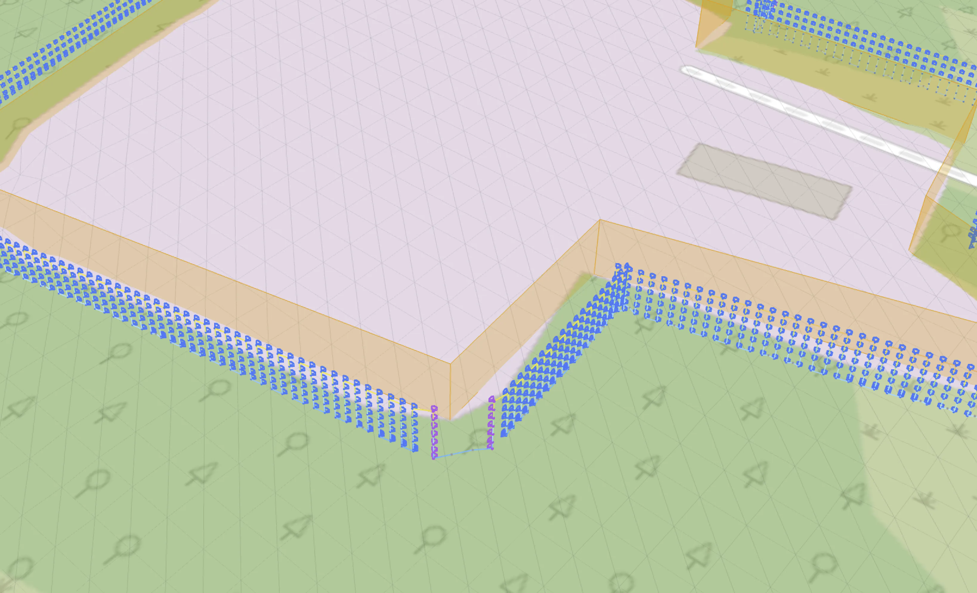
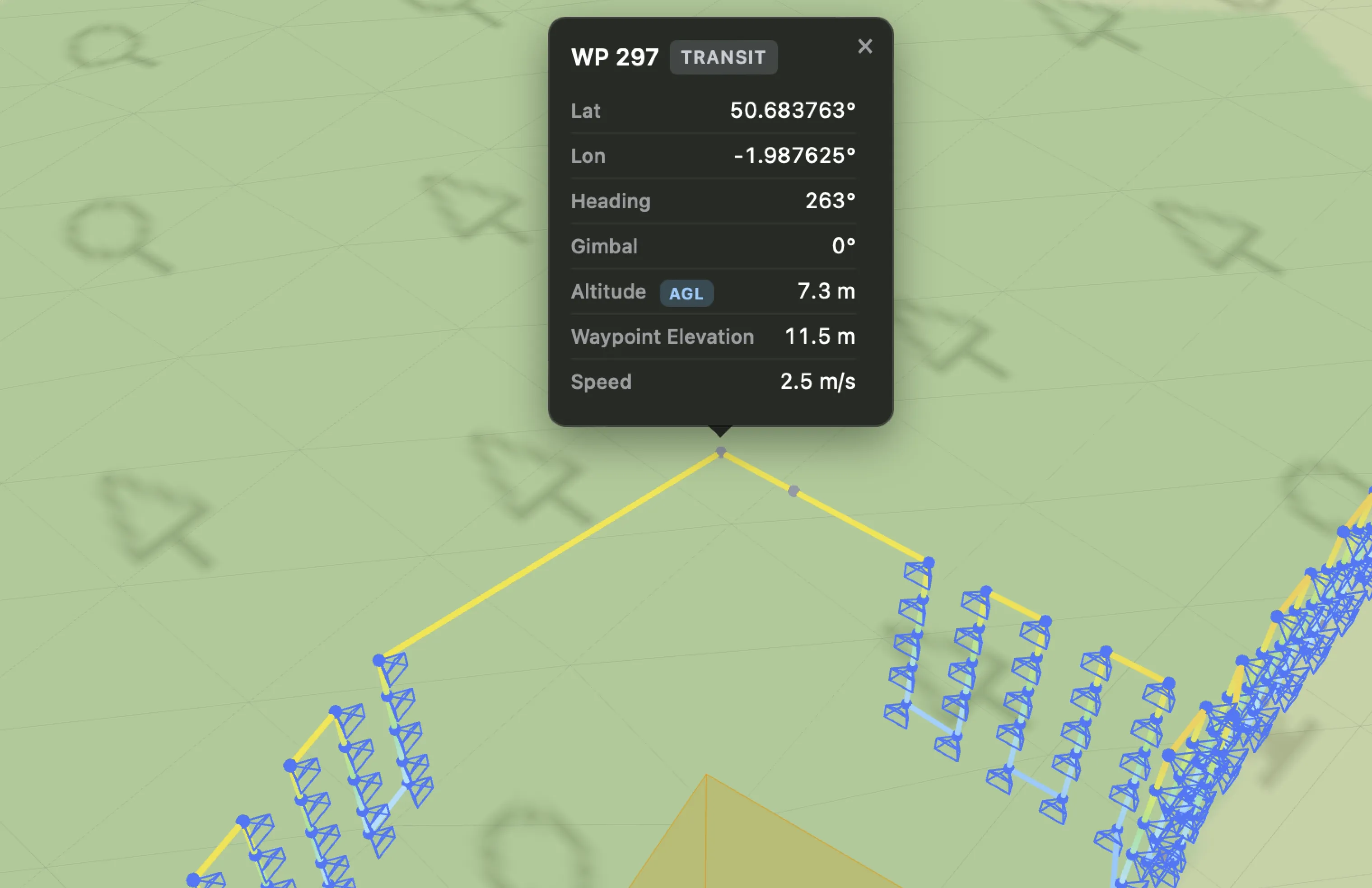
Obstacle-checked routing, honestly reported
Every flight leg is validated against the structure and the terrain. Legs that would cut through a wall, graze a corner or dip below your safety floor are repaired with detour waypoints — around the building by default, or over the roofline with your chosen clearance if you allow it. Steep terrain counts as an obstacle too. And when a tight pocket genuinely can't be reached at your standoff, the station is skipped and reported, not silently flown into. You verify the whole route in the interactive 3D preview before anything takes off.
Capture the roof too (Advanced)
Close the outline into a polygon and switch on Capture the Roof: the top opening is patched between the wall tops — each vertex at its own top offset, so sloped tops give a sloped roof — and flown as a grid at your standoff after the walls, the camera square to each roof plane. Every wall column climbs over the eave with convergent corner shots, and a ridge or valley drawn into the outline gets the same treatment. Overlaps, GSD and obliques carry over, and the roof shots are reported separately in the mission stats.
Intelligent Obliques for complete geometry
Straight-on photos alone reconstruct flat walls poorly around openings and reliefs. With Intelligent Obliques enabled, each point on the wall can also be photographed from angled directions you pick on a 3×3 grid — pairs fire together, and each column is flown as one uninterrupted climb so the oblique sequence survives the flight order. The result is the tie-point density that crisp, complete 3D geometry needs.
Terrain-aware by construction
Façade missions don't have a terrain-follow toggle because they don't need one: every column is referenced to the ground beneath it, with a minimum height to ground and per-edge clearances you control. For the best results on sloped sites, upload a bare-earth DTM from a quick preliminary survey — it becomes the planner's highest-priority elevation source, processed entirely in your browser.
See the plan against the real surroundings
The routing validates every leg against the wall you traced and the terrain — but a façade rarely stands alone. Load a mesh of the site as a 3D Model Overlay — from a quick oblique pass processed in WebODM or Metashape — and it appears seated on the terrain in the 3D preview, so you can visually confirm the columns and transit legs clear the neighbouring trees, sheds and wires the planner doesn't know about. On the 2D map, a GeoTIFF orthomosaic overlay lets you trace the façade line itself with pixel accuracy. Both are visual references, processed entirely in your browser and never uploaded. More on planning with real-world context →
Flown on the drone you already own
Export is a standard DJI KMZ (WPML) waypoint mission — flown natively by a Mini 4 Pro, Mini 5 Pro, Air 3/3S, Mavic 3 series, Mavic 4 Pro or Lito X1 through DJI Fly (Matrice 300/350 RTK, Mavic 3E/3T/3M and Inspire 3 pilots import the same file in DJI Pilot 2 as a stop-and-shoot wayline), with an experimental Litchi CSV option for waypoint missions. Long façades split automatically into numbered flights at your waypoint cap.
Façade missions, asked and answered
Can a DJI Mini really fly a façade mapping mission?
Yes. The mission exports as a standard DJI KMZ (WPML) waypoint file that a Mini 4 Pro or Mini 5 Pro flies natively through DJI Fly — the planning intelligence lives in the mission file, not on the drone.
How does it avoid hitting the building?
Every leg between camera stations is validated against the structure and terrain, and repaired with detour waypoints where it would cut a corner or graze a wall. Stations that can't be reached safely at your standoff are skipped and reported — never silently flown. Your drone's onboard obstacle sensing stays active as the final safety layer.
What accuracy should I expect on the wall?
You set a ground sampling distance on the vertical surface (or a standoff distance — they're linked), and achieved overlap is always at least what you requested. In flight, a consumer drone holds the planned positions to GNSS accuracy (typically ±2–3 m) — the error drifts slowly, so overlap holds up well, but true standoff and GSD move with it: keep your standoff and clearance margins above that budget. An RTK Matrice 300/350 holds position to centimetres, and the planner relaxes its margin warnings when you select one. Final model quality still depends on your camera, light and the reconstruction software.
Does it capture the roof as well?
It can (Advanced). Close the outline into a polygon and switch on Capture the Roof: the top opening is patched between the wall tops — each vertex at its own top offset, so sloped tops give a sloped roof — and flown as a grid at your standoff after the walls, the camera square to each roof plane, with corner shots over every eave and along any ridge or valley in the outline. The roof is a model built from the wall tops, so a ridge rising above them is unknown to the planner: raise the top offsets on the ridge-side vertices or keep the standoff generous.
Other mission types
Plan your first façade mission
Create a free account, trace a wall and preview the route in 3D.